Nauru
Veröffentlicht: 19. June 2022 - Letztes Update: 28. February 2025
Country Data Dashboard
Population
9,892
Growth: 0.39% (2024 est.)
GDP
$154.17 million
(2023 est.)
Area
21 sq km
| Government type: | parliamentary republic |
| Capital: | no official capital; government offices in the Yaren District |
| Languages: | Nauruan 93% (official, a distinct Pacific Island language), English 2% (widely understood, spoken, and used for most government and commercial purposes), other 5% (includes Gilbertese 2% and Chinese 2%) (2011 est.) |
People & Society
Ethnicity (2021 est.)
Religion (2021 est.)
Age structure
No image available.
Economy
Economic overview
upper-middle-income Pacific island country; phosphate resource exhaustion made island interior uninhabitable; licenses fishing rights; houses Australia’s Regional Processing Centre; former tax haven; largely dependent on foreign subsidies
Real GDP (purchasing power parity) in Billion $
Real GDP per capita in $
Exports & Imports in million $
Top 5 Import Partner in 2022 (89%)
Top 5 Import Commodities in 2022
- ships 🚢
- plastic products ♻️
- other foods 🍽️
- cars 🚗
- refined petroleum ⛽
Top 5 Export Partner in 2022 (89%)
Top 5 Export Commodities in 2022
- fish 🐟
- phosphates ⛏️
- gas turbines 🌀
- power equipment 🔋
- plastic products ♻️
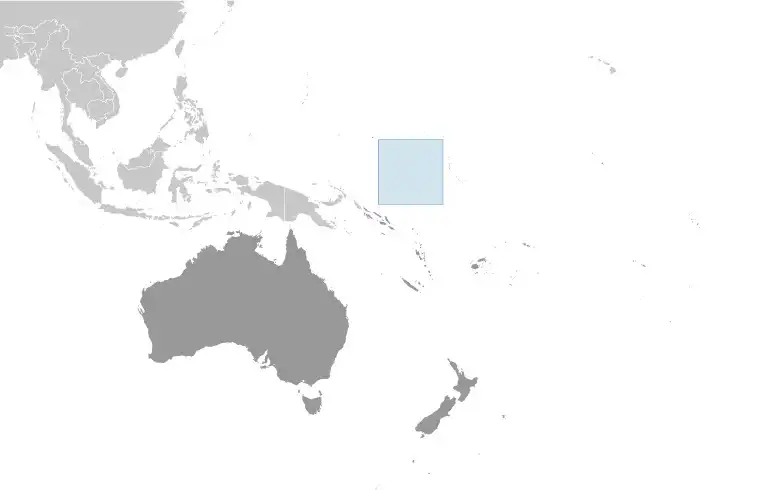
Geography
Map
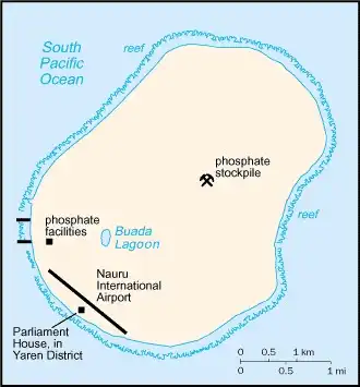
Area
Natural resources
- phosphates ⛏️
- fish 🐟
Climate
tropical with a monsoonal pattern; rainy season (November to February)
Historical Background Information
By 1000 B.C., Micronesian and Polynesian settlers inhabited Nauru, and the island was divided among 12 clans. Nauru developed in relative isolation because ocean currents made landfall on the island difficult. As a result, the Nauruan language does not clearly resemble any other in the Pacific region. In 1798, a British mariner was the first European to spot the island and by 1830, European whalers used Nauru as a supply stop, trading firearms for food. A civil war in 1878 reduced the population by more than a third. Germany forcibly annexed Nauru in 1888 by holding the 12 chiefs under house arrest until they consented to the annexation. Phosphate was discovered in 1900 and was heavily mined, although Nauru and Nauruans earned about one tenth of one percent of the profits from the phosphate deposits.
Australian forces captured Nauru from Germany during World War I, and in 1919, it was placed under a joint Australian-British-New Zealand mandate with Australian administration. Japan occupied Nauru during World War II and used its residents as forced labor elsewhere in the Pacific while destroying much of the infrastructure on the island. After the war, Nauru became a UN trust territory under Australian administration. In 1962, recognizing the phosphate stocks would eventually be depleted, Australian Prime Minister Robert MENZIES offered to resettle all Nauruans on Curtis Island in Queensland, but Nauruans rejected that plan and opted for independence, which was achieved in 1968. In 1970, Nauru purchased the phosphate mining assets, and income from the mines made Nauruans among the richest people in the world. However, a series of unwise investments led to near bankruptcy by 2000. Widespread phosphate mining officially ceased in 2006.
As its economy faltered, Nauru briefly tried to rebrand itself as an offshore banking haven, an initiative that ended in 2005, and the country made a successful bid for Russian humanitarian aid in 2008. In 2001, Australia set up the Nauru Regional Processing Center (NRPC), an offshore refugee detention facility, paying Nauru per person at the center. The NRPC closed in 2008 but reopened in 2012. The number of refugees steadily declined after 2014, and in 2020, the remaining people were moved to Brisbane, Australia, effectively shuttering the NRPC. However, in 2023, Australia agreed to continue funding NRPC for two years and restarted settling asylees in the center in mid-2023. The center remains the Government of Nauru’s largest source of income.